The Storied Past of the Nantahala River
The Nantahala River, with its frothy, white-capped waters slicing through the lush greenery of western North Carolina, stands as a global beacon for adventure seekers. Nestled within the verdant embrace of the Nantahala National Forest, this river draws enthusiasts for whitewater rafting, kayaking, canoeing, hiking, fishing, and swimming. Despite the rise of commercial ventures along its banks, the river retains an untamed allure. Standing on its shores, with the roar of the current and the whisper of the breeze, one can almost hear the echoes of ancient times when the river flowed freely and the voices of ancestors reverberated across the misty peaks.
Origins and Flow
The Nantahala River springs to life high in the Great Smoky Mountains, born from pristine springs near Wayah Bald, close to the iconic Appalachian Trail. These waters gather from tributaries like Indian Creek, Kimsey Creek, Johnson Branch, Morris Branch, Mooney Creek, Long Branch, and Laurel Branch, converging to form the mighty Nantahala. The river then feeds into Fontana Lake, where it mingles with the Little Tennessee and Tuckasegee Rivers. From there, its journey continues through the Ohio River, down the Mississippi, and ultimately into the Gulf of Mexico, connecting the highlands of North Carolina to the distant sea.
Near Beechertown, at the rafting put-in point, the upper Nantahala takes a dramatic turn. Geological forces, spurred by erosion from increased water flow, carved the Nantahala Gorge, diverting the river from its original path toward the Cheoah River. The name “Nantahala,” often romantically interpreted as “Land of the Noonday Sun” due to the gorge’s steep walls that obscure sunlight until midday, actually derives from the Cherokee word Nundayeli, meaning “noon.”
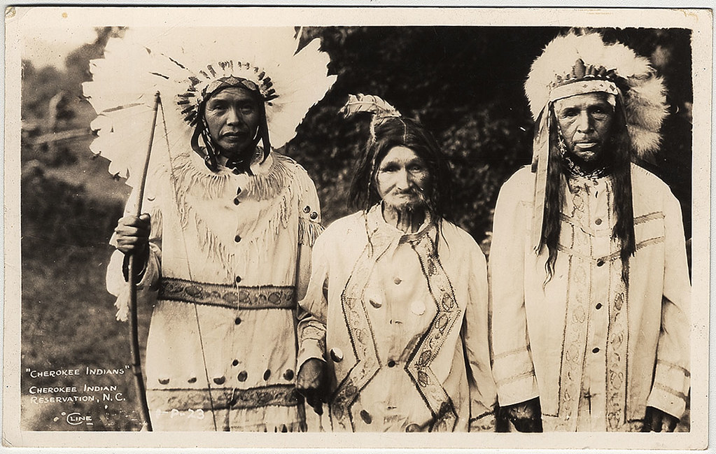
Cherokee Heritage
The Cherokee Nation, with roots tracing back at least 15,000 years, thrived along the Nantahala River long before European contact. They cultivated crops, hunted game, and crafted pottery and tools along its banks, leaving a legacy still honored by their descendants. The river valley was a stronghold during the tragic Trail of Tears, following the Indian Removal Act of 1830, which forcibly displaced many Cherokee. Some resisted, and those who remained or evaded removal formed the foundation of the Eastern Band of Cherokee Indians, now based in nearby Qualla Boundary.
The Cherokee were a sophisticated society, developing a syllabary in the early 19th century through the genius of Sequoyah. This written language, still used by the Eastern Band, Cherokee Nation of Oklahoma, and United Keetoowah Band, preserves their cultural heritage. Archaeological sites along the river, including remnants of villages and ceremonial mounds, attest to their deep connection to the land.
Early Settlers and Industry
European settlers began arriving in the Nantahala region in the 1800s, drawn by its fertile lands and abundant resources. Among them was Colonel Nimrod S. Jarrett (1799–1871), a prominent figure in Macon County. Jarrett amassed wealth through farming, trading ginseng, and operating talc and mica mines. His life ended tragically when he was murdered during a robbery attempt while traveling to Franklin. His wife, Nancy Avaline McKee, played a pivotal role in ensuring the perpetrator faced justice.
The Fry family also left their mark, with Frank Fry overseeing operations at the North Carolina Talc and Mining Company (later known as Hewitt’s) along the river. This quarry, still active under a different name, was a cornerstone of the local economy. Fry’s ventures extended into the lumber industry, capitalizing on the region’s vast forests.
Percy Ferebee, a later figure, significantly shaped the river’s modern legacy. A U.S. Forest Service engineer who settled in Andrews, North Carolina, in 1913, Ferebee donated 6,000 acres to the Forest Service in 1971. This act preserved public access to the Nantahala River and its surrounding wilderness, safeguarding it from overdevelopment and ensuring its recreational future.
Logging and Early Resource Use
In the late 19th century, the Nantahala’s powerful currents were harnessed by loggers to transport timber to sawmills. During late winter and early spring floods, massive logs were floated downstream, but this practice often wreaked havoc, destroying bridges, roads, and buildings. Wealthy landowners Matthew and Sarah Cole, near the modern rafting put-in, leased land to the Nantahala Lumber and Manufacturing Company for a reservoir to store logs. The chimney of their 1870s farmhouse still stands across the river, a silent testament to a bygone era of settlement and industry.
Exploration and Natural Wonders
The Nantahala’s natural beauty attracted early explorers like William Bartram, a botanist who visited in the 1770s. Bartram documented the region’s rich biodiversity, noting species like dogwood, white oak, mountain camellia, ginseng, and the elusive bog turtle. He also discovered morel mushrooms, branch lettuce, and kaolin deposits—a “clear white earth” used in porcelain production. His journey inspired the Bartram Trail, a hiking path that traces his route through the Nantahala wilderness hunting ground for artifacts (e.g., arrowheads, pottery) is limited due to the sensitive nature of archaeological sites.
The Dam and Modern Recreation
The construction of the Nantahala Dam in 1942, built to support World War II defense projects and provide electricity, transformed the river’s role. The dam created Fontana Lake and stabilized water flows, inadvertently boosting recreational opportunities. One iconic spot, Patton’s Run, marks the start of the river’s Class II rapids. Named for Charlie Patton, a one-armed postman and canoe instructor at Camp Mondamin, this rapid remains a favorite among beginners.
Commercial rafting began in 1972, and companies like Carolina Outfitters, established in the early 1980s, obtained permits to guide visitors down the river. The rafting season, spanning mid-March to late October, attracts thousands annually. The Nantahala Outdoor Center (NOC), founded in 1972, has become a hub for adventure tourism, offering guided trips, instruction, and gear rentals. In 2024, the NOC reported hosting over 500,000 visitors, underscoring the river’s draw. The Nantahala’s eight-mile whitewater stretch, with Class II and III rapids like Nantahala Falls, offers thrills for novices and experts alike.
A Living Legacy
The Nantahala River is more than a playground; it’s a tapestry of history, culture, and nature. From Cherokee resilience to settler ingenuity, from logging’s rough-hewn past to modern eco-tourism, the river weaves a story of endurance and beauty. Visitors can explore this heritage at sites like the Cherokee Heritage Museum or hike trails like the Appalachian or Bartram, where the forest hums with life. For deeper insights, The Nantahala River: A History & Guide by Lance Holland is a must-read, available at the Nantahala General Gift Shop near Carolina Outfitters.
Whether paddling through the gorge, fishing for trout, or simply standing by the water’s edge, the Nantahala offers a timeless escape. Its mountains, rivers, and trails beckon, promising peace and adventure in equal measure.