Kayaking and Rafting the Nantahala River Gorge: A Comprehensive Guide
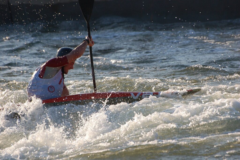
The Nantahala River, flowing through western North Carolina’s Nantahala National Forest, is a premier destination for whitewater kayaking and rafting. Known as the “Land of the Noonday Sun” due to its deep, shaded gorge, the river offers a mix of beginner-friendly Class II-III rapids and challenging Class IV-V sections. This article provides a detailed guide to the Nantahala Gorge’s rapids, put-ins, take-outs, and key considerations for paddlers, covering the Nantahala Cascades, Upper Nantahala, and Lower Nantahala sections.
Overview of the Nantahala River
The Nantahala River stretches approximately 8 miles through the Nantahala Gorge, with additional upper sections above the gorge. Controlled by Duke Energy’s Nantahala Dam, the river maintains consistent flows, making it reliable for paddling from March to October. The water, released from the bottom of Nantahala Lake, is cold (around 50°F), so wetsuits are recommended, especially for kayakers and those in inflatable kayaks (“duckies”). The river is divided into three main sections for paddlers:
- Nantahala Cascades: A steep, expert-level Class IV-V section.
- Upper Nantahala: A scenic Class III-IV run with limited releases.
- Lower Nantahala: A popular Class II-III section ideal for families and beginners.
Paddling requires a USFS Nantahala River Permit for private boaters, available at the Nantahala Outdoor Center (NOC) or Endless River Adventures. Safety is paramount due to cold water, swift currents, and occasional hazards like foot entrapments. Since 1990, eight fatalities have been recorded, primarily from foot entrapments and flush drownings, though the river’s safety record is strong given its high traffic (over 200,000 paddlers annually).
Put-Ins and Take-Outs
Nantahala Cascades and Upper Nantahala
- Upper Put-In (Cascades): Located just below Whiteoak Falls on Wayah Road, 3.4 miles past the Wayah Road turnoff from US 19/74. Limited parking is available near the bridge over the river. This put-in is used for the Cascades and Upper Nantahala runs, primarily during Duke Energy’s recreational releases (several times each summer). A free shuttle operates during festival weekends.
- Cascades Take-Out/Upper Put-In: Found just south of Nantahala, NC, on Wayah Road, immediately after turning off US 74/19. Park in the lot to the left or across in the grass lot if full. This serves as the take-out for the Cascades and the put-in for the Upper Nantahala.
- Wayah Road Put-In (Lower Nantahala): Located 7.9 miles up Wayah Road from US 19/74, near the raft launch site across from the Nantahala Power Station. This is the primary put-in for the Lower Nantahala, offering parking, restrooms, and easy river access. It’s close to Patton’s Run, so paddlers must be ready immediately.
- Ferebee Memorial Picnic Area: An alternate put-in 5.3 miles up US 19/74 from the NOC, ideal for a shorter Lower Nantahala run (about 1 hour less). It skips Patton’s Run but includes most other rapids.
Lower Nantahala
- Nantahala Gorge Boat Ramp: A secondary access point near the Ferebee Memorial Picnic Area, used by some outfitters for shorter trips.
- NOC Takeout: The primary take-out for the Lower Nantahala, located at the Nantahala Outdoor Center (715 Hwy. 19 W, Topton, NC). This bustling hub offers parking, dining, and a playspot below Nantahala Falls, site of the 2013 Freestyle World Championships.
- Big Wesser Takeout: Below the NOC, this is an alternate take-out for those running the Class IV Lower Nantahala Falls (Wesser Falls), a steep, rocky rapid not typically run by commercial groups. Scout from the NOC take-out before attempting.
Rapids of the Nantahala River
Nantahala Cascades (Class IV-V)
The Cascades, located just below Whiteoak Falls, is a steep, narrow section runnable only during Duke Energy’s recreational releases (typically 250-400 cfs, with higher flows up to 1,000 cfs possible). It’s a short but intense run for expert kayakers, featuring tight lines and significant hazards.
- Horns of God (IV+): At mile 0.3, this rapid has a tricky entrance with a hole to avoid. The main line runs between two “horns,” ramping to a boof, or far left along a curler seam. A downstream ledge offers another boof. Watch for the hole below the entrance, which can flip boats.
- Big Kahuna (V): At mile 0.4, this is the crux of the Cascades. It’s a complex rapid with powerful hydraulics and multiple lines, requiring precise navigation. At higher flows (600+ cfs), holes become aggressive, and the rapid feels continuous.
- Chinese Feet (IV to IV+): At mile 0.5, this two-step rapid offers several lines. The right line involves boofing a ledge with a left angle, avoiding a pocket eddy at the base of an inflow. A middle boof near a log hazard is riskier, while the left line into an eddy is easier but requires a clean exit.
- Runout (III to IV-): Below Chinese Feet, the runout is rocky and scrappy at lower flows (250-300 cfs), with potential for boat damage. At 400 cfs, it’s more padded and fun.
Concerns: The Cascades is for advanced paddlers only due to its steep gradient, tight channels, and cold water. Flows above 600 cfs increase difficulty, and low flows (below 300 cfs) make it boney. Scout all rapids, as hazards like logs can appear.
Upper Nantahala (Class III-IV)
The Upper Nantahala runs from the Cascades take-out to the Wayah Road put-in, typically paddled during releases or after heavy rain. At 450 cfs, it’s a solid Class III-IV run, but lower flows are rocky, and higher flows (600+ cfs) add continuous difficulty.
- PB&J (III+): At mile 0.7, this rapid features boogie water leading to a sloping hole on the right, fun to drop into at 450 cfs. Avoid it to the left for a mellower line.
- Camp Branch Falls Rapid (III+): Near mile 0.8, this rapid is associated with Camp Branch Falls, a roadside waterfall visible from Wayah Road. It’s a straightforward drop with a clean wave-train.
- Jungle Boogie (III): A fun, wavy section with playful boofs and eddies, ideal for practicing moves. It’s less distinct but adds to the run’s continuous feel.
- Bridal Veil (III): A scenic rapid with a smooth, curving wave, offering a chance to surf or ferry. It’s named for its graceful flow, resembling a veil.
- Troll Hole/Fuzzy Bunny (III+): At mile 0.9, near a bridge, this is the final major rapid. Boof the middle hole, avoiding a rock on the far left. The hole packs a punch at higher flows.
Concerns: The Upper Nantahala is less frequented, so paddlers may encounter fewer boaters for support. Low flows (below 450 cfs) are boney, while high flows increase hazards for Class III-IV paddlers. Cold water and remoteness require preparation.
Lower Nantahala (Class II-III)
The Lower Nantahala, from Wayah Road to the NOC, is the most popular section, with over 20 named rapids across 8 miles. It’s ideal for families (minimum age 7 or 60 lbs) and beginners, with consistent Class II-III rapids and a Class III finale at Nantahala Falls.
- Patton’s Run (II+): At mile 0.1, this rapid comes quickly after the Wayah Road put-in. A sharp right curve requires staying hard right to avoid a large boulder on the left. It’s a wake-up call for new paddlers.
- S-Turn (II): A fun, weaving rapid with eddies and waves, perfect for practicing ferries and eddy-hopping. It’s forgiving but engaging.
- The Mank (II): A straightforward rapid with a small ledge and wave-train, named for its tendency to “mank” (bump) boats around.
- Island Rapid (II): Features a small island splitting the flow. The right channel is typically cleaner, with a wavy runout.
- Quarry Rapid (II): At mile 3.2, near a gravel factory, this rapid has a nice wave-train down the middle, ideal for beginners to practice.
- Whirlpool (II+): A playful rapid with a swirling eddy, great for practicing rolls or stern squirts. Some paddlers find it tricky due to its grabby nature.
- The Bump (II+): At mile 7.4, marked by a sign on the left shore, this rapid has a small, sticky ledge hole on the left. Run right to avoid it or boof the hole for practice. It’s a good spot to hone skills.
- Nantahala Falls (III): At mile 7.55, this is the Lower Nantahala’s climax. Two offset holes create a challenging line: start left of center to skirt the stickier top hole, then drive hard right to avoid the larger bottom hole. Misjudge the top hole, and you risk spinning or flipping. Scout from the right bank.
- Big Wesser (IV): Below the NOC take-out, this is the Lower Nantahala Falls (Wesser Falls), a steep, rocky Class IV drop at a 45-degree angle. Rarely run by commercial groups, it’s for advanced kayakers. Scout thoroughly, as sharp rocks pose risks.
Concerns: The Lower Nantahala is busy, especially on summer weekends, with up to 150,000 boaters annually. Watch for crowded conditions, especially at Nantahala Falls. Cold water requires proper gear, and foot entrapments are a risk—always float on your back with feet up if swimming. The section is pet-friendly (dogs 35+ lbs allowed with some outfitters), but pets are not permitted on shuttles or rental equipment.
Other Features and Considerations
Nantahala River Bike Trail and Lower River Bike Trail
- Nantahala River Bike Trail: A 2-mile (out-and-back) paved, pet-friendly trail starting near the Wayah Road put-in, accessible via a footbridge. It follows the river, offering scenic views for walkers, bikers, and strollers. Ideal for non-paddlers or post-paddle relaxation.
- Lower River Bike Trail: Less defined but refers to paths and pull-offs along US 19/74 near the NOC, used by spectators watching paddlers at Nantahala Falls or the Championship Wave playspot.
Wayah Road
Wayah Road parallels the Upper and Lower Nantahala, offering access to put-ins, take-outs, and scenic pull-offs. It’s a winding, scenic drive with views of cascades, waterfalls (like Camp Branch Falls), and trout fishing spots. Motorcyclists and drivers should be cautious of paddlers’ vehicles and pedestrians.
Camp Branch Falls
A roadside waterfall on Wayah Road near the Upper Nantahala, visible from a pull-over. It’s not directly paddleable but marks the area of the Camp Branch Falls Rapid. Reaching the falls requires climbing rugged boulders, so exercise caution.
Safety and Logistics
- Cold Water: The 50°F water necessitates wetsuits, especially for kayakers and ducky paddlers. Outfitters rent wetsuits and paddling jackets.
- Permits: Private boaters need a USFS permit, available at NOC or Endless River Adventures.
- Outfitters: Over a dozen outfitters (e.g., NOC, Adventurous Fast Rivers, Wildwater) offer guided and unguided trips, rafts, duckies, and kayaks. Reservations are recommended, especially for July and Saturdays.
- Gear: Wear secure shoes (no flip-flops), quick-drying clothes, and a properly fitted PFD. Avoid cotton in cooler weather.
- Hazards: Foot entrapments and undercut rocks (e.g., Turtle Rock) are rare but serious risks. Scout Nantahala Falls and Big Wesser carefully.
- Crowds: The Lower Nantahala can feel like an “amusement park ride” on busy days, so plan for early or late trips to avoid congestion.
- Environmental Respect: No coolers are allowed on the river, and paddlers should pack out all trash to preserve the Nantahala’s pristine environment.
Conclusion
The Nantahala River offers a spectrum of paddling experiences, from the expert-only Cascades to the family-friendly Lower Nantahala. With consistent dam releases, stunning scenery, and a range of rapids, it’s no wonder the river attracts Olympians, beginners, and everyone in between. Whether you’re boofing Big Kahuna, surfing The Bump, or splashing through Nantahala Falls, preparation is key: secure a permit, dress for cold water, and respect the river’s power. The Nantahala Gorge, with its bike trails, waterfalls, and vibrant outdoor culture, is a paddler’s paradise—plan your trip, paddle smart, and enjoy the ride.
Sources:
- Great Smokies:
- A Wet State:
- Nantahala Outdoor Center:
- Carolina Canoe Club:
- Visit Nantahala NC:
- Romantic Asheville:
- Adventurous Fast Rivers:
- Thunderbird Mountain Cottage:
- TripAdvisor:
- Blue Ridge Motorcycling Magazine:
- Wildwater Rafting:
- Rolling Thunder River Co:
- Wikipedia: